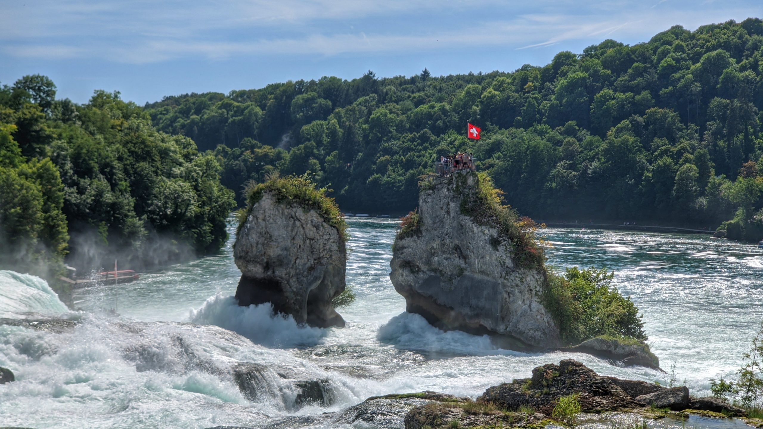
For the way it is advisable to complete the route to Schaffhausen on the right bank of the Rhine. The only slightly larger slope is at the beginning of the tour.

So you start at the town hall square of Stein am Rhein, drive through the pretty city center and leave it via Hemmishofer Straße. The branch to the youth hostel is ignored and it is better to take the smooth cycle path along the road, cross under the main road and turn left into Dorfstraße in the small town of Hemmishofen. On this you leave the houses again and cycle through fields to the beaver mill on the tributary of the Rhine of the same name.

Before the bridge, a gravel path leads to the left to a nice bathing spot on the banks of the Rhine. After the beaver bridge it goes uphill to the turnpike of the German-Swiss border in the middle of the forest. With that, the toughest climb of the day is already done.

Rolling down, it goes to the Rheinstrandbad in Gailingen and a short distance directly along the Rhine to the covered wooden bridge over to Diessenhafen. The cycle path remains on the right bank of the Rhine and continues to Büsingen, crossing the border twice.

Büsingen is driven through on Junkerstraße, which leads back to Switzerland as Schaffhauser Straße at the end of the village.

After the border, the street is called Rheinhaldenstraße and continues along the Rhine into the inner city of Schaffhausen. After passing under the railway bridge high above the valley, you come to the Freier Platz on the edge of the old town.

An underpass for cyclists and pedestrians leads from the Freier Platz under the Rhine bridge and continues along the Rhine to the motorway underpass. We continue along the Rhine for a while until a sign at Flurlinger Steg points back sharply to the right. It's a steep uphill. Then through the underpass of the Neuhauser train station up to the forecourt.

Continue uphill on Rheinstrasse until Laufengasse leads steeply down to the Rhine Falls.

To get to the other side of the Rhine as a cyclist, you push your bike a little on the narrow promenade and over the railway bridge. Those who do not want to push can continue downriver from Schlössli Wörth to Nohl, cross the Rhine on the footbridge and crank the short, steep cut up to Dachsen.

Beyond the railway line, the pebbled Rheinfallweg leads along it - or alternatively the street - to Laufen Castle.

Back to Stein am Rhein you cycle from Laufen Castle back up the Rhine to the Flurlinger Steg, which connects the town of the same name with Neuhausen.

After Schaffhausen the same route is used as on the way there until the free space is reached again. Now on the road bridge over the Rhine and along the busy main road 13 a little uphill to Feuerthalen.

At the large intersection with traffic lights, Konstanzerstraße turns left and bypasses a good part of the noisy Diessenhofer Straße.

Again on this cycle past the lido and campsite further up the Rhine. Shortly after Langwiesen, the Klostergutstraße branches off to the left and leads back closer to the Rhine to the Paradies monastery.

Since Schaffhausen, the route described here has followed the Swiss Rhine Route (National Veloroute 2). The bike path leads away from the Rhine in a slight incline and curves around the monastery buildings.

It goes through fields over to the edge of the forest and from then on on a pleasantly shady and level route through the so-called Schaaren forest to the Katharinenthal monastery, directly on the banks of the Rhine.

On the access road it goes up a bit, then left in an S-curve down through the Asylweg and back to the Rhine.

A footbridge takes you to Rheinstrasse and keeping left along the banks of the Rhine back to the wooden bridge to Gailingen.

On the Steinerstraße it goes out of Diessenhafen to the historic Gasthaus Schupfen. There you come back to Hauptstraße 13 and drive along it for a while to Rheinklingen.

The Rhine valley is surprisingly narrow here. The wooded slopes reach down to the course of the river and even leave little room for the road to get through.

Before the pretty little farming village, the cycle path branches off to the left again and leads through the village.

The road to Singen and the former railway line are crossed under and you are already standing in front of the first houses in Wagenhausen. On the main road, it goes a little through the village before the bike path meanders through the Gässli and Espiweg back to the starting point at the Rhine bridge in Stein am Rhein.
Official representation of the Lake Constance cycling path